Water Quantity and QUALITy:
103D Projects & programs
The Bois de Sioux Watershed District has many active projects in various states of development and construction, authorized by Minnesota Statute Chapter 103D. The District uses the Flood Damage Reduction Work Group's Project Team approach to design and develop projects.
The Red River Basin Technical and Scientific Advisory Committee (BTSAC) Briefing Papers have been developed by a collaborative team and provide shared technical standards utilized by the Bois de Sioux Watershed District and other Red River Basin watershed districts.
Water Quantity, Storage & Impoundments
 Redpath Flood Impoundment (Under Phased Construction), please see below
Water Quality & Sediment Control
Multi-Benefit Stream/River Rehabilitations & Restorations
Impoundments
Impoundments are an important tool to provide water storage during flood events, reducing damages to roads, bridges, drainage systems, businesses, homesteads, and agricultural lands. Impoundments are also an opportunity to provide habitat to migrating species, and provide a tourist destination for bird watching. Although packed with benefits, impoundments are complicated projects, involving many landowners, many permitting agencies, and many funding partners.
The Bois de Sioux Watershed District has completed one impoundment project (North Ottawa Flood Impoundment), and is in the process of finishing a second (the Redpath Flood Impoundment and associated Mustinka River Rehabilitation Project). This projects are significant bird and wildlife watching destinations. The Mustinka River Rehabilitation Project is complete and open to the public. This project was supported with funds from a variety of sources, including: Clean Water Fund Board of Soil and Water Resources; the Red River Watershed Management Board; Legacy Amendment Legislative-Citizen Commission on Minnesota Resources; Legacy Amendment Lessard Sams Outdoor Heritage.
Letters of Support:
North Ottawa Flood Impoundment
The North Ottawa Flood Impoundment Project began in 1989; construction was completed in 2016. This facility provides storage for spring floods, and is utilized year-round to provide natural resource enhancements - including unique opportunities for bird and waterfowl watching.
More information about the North Ottawa Impoundment (and visiting) can be found here. A printable version is available here.A description of how the cells were used in 2022 is available here.
Directions: Located at 45.992261, -96.255545 https://goo.gl/maps/wZYVpxijhQR8p9AV8
From I-94: Take Exit 100, and head west on State Highway 27. Drive approximately 36 miles to Herman. At the four-way stop in Herman, take a right/head northwest onto State Highway 9. Drive 14.5 miles. Take a right/head east onto Grant County 95 for 2.5 miles.
From Wendell: Take County Road 11 south out of Wendell for 2.6 miles. Take a right/head west onto Grant County 42. Drive 7.5 miles.
From Fargo/Moorhead: Take Highway 75 south. Just before Doran, MN, follow the split for State Highway 9 and continue along State Highway 9 for 18.2 miles. Turn left/head east onto Grant County 95 for 2.5 miles.
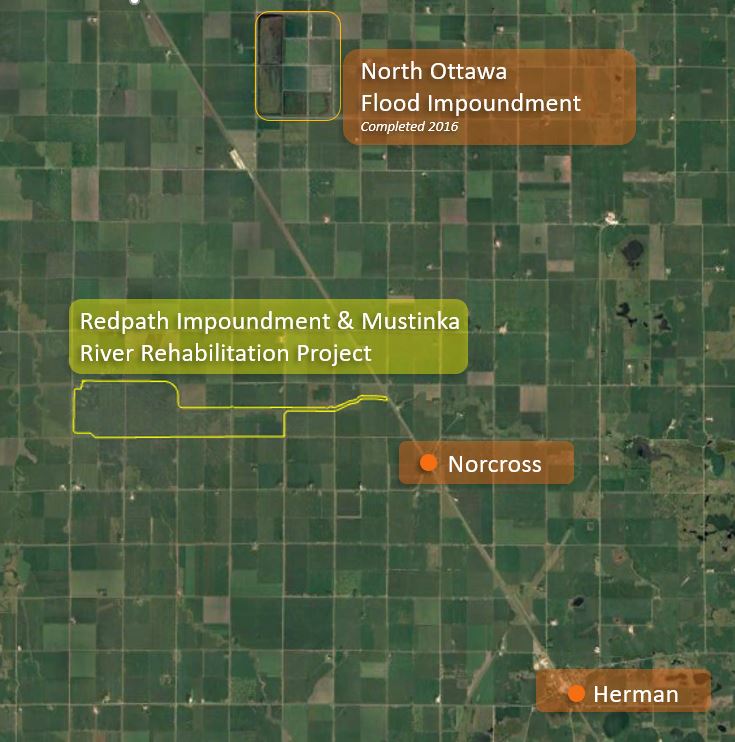
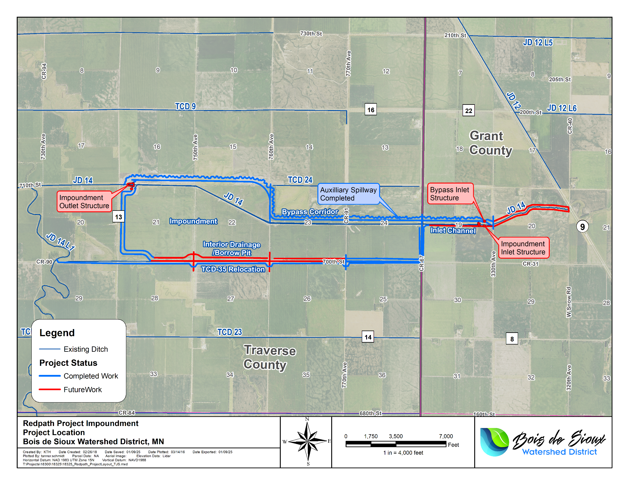
Redpath Flood Impoundment & Mustinka River Rehabilitation Project
For years, the Mustinka River in Traverse and Grant County, Minnesota has been the source of significant flooding caused primarily by spring snowmelt events. These floods have resulted in extensive damage to infrastructure, including roads, bridges, and culverts, and threatened rural homes and agricultural land. Since 2008, the Bois de Sioux Watershed District has been working toward a multi-purpose solution known as the Redpath Impoundment & Mustinka River Rehabilitation Project. After years of study, permitting, and land acquisition, the Watershed District is thrilled to announce that project construction is nearing completion.
COMPLETED AND FUTURE WORK
As seen in the project map below, significant construction progress has occurred since the first bid letting in 2022. Construction is over half complete. Remaining tasks include 2 ½ miles of levee construction along the south perimeter, inlet channel, and structures.
STATE FUNDING REQUEST
To date, $36.8 M has been spent on this $62.5 M project, including $9.9 M from the Minnesota Flood Hazard Mitigation (MNFHM) program. An additional $13.7 M in funding is required through the MNFHM program to bring this project to completion and protect the region’s economy, citizens and natural resources from future flooding.
The Redpath Flood Impoundment and Mustinka River Rehabilitation Projects are located in Traverse and Grant Counties, northwest of Norcross, Minnesota. Over five miles of the Mustinka River has been re-meandered within a two-stage constructed flood corridor channel. The design recreates a natural river sinuosity with flow controls that stabilizes the channel and protect it from future erosion. Materials excavated from the rehabilitated Mustinka River two-stage channel have been used to build the north, east and west levies of the Redpath flood impoundment. This project has received widespread support (from landowners, Grant & Traverse Counties, and state agency representatives).
PROJECT BENEFITS
The completed project will:
• Protect rural communities and agricultural areas from devastating floods.
• Prevent costly damage to roads, bridges, culverts and other infrastructure.
• Mitigate economic losses from flood-related disruptions.
• Establish vast natural resources enhancements open to the public.
• Improve water quality within the Mustinka River and receiving waters.
• Address climate change to create a more resilient future.
Financial Awards:
Financial awards have been provided by the State of Minnesota Lessard Sams Outdoor Heritage Council Fund, the State of Minnesota Legislative-Citizen Commission on Minnesota Resources from the Minnesota Environment and Natural Resources Trust Fund, the State of Minnesota BWSR Clean Water Fund Legacy Amendment Act Projects and Practices and Mutlipurpose Drainage Management and Water Quality & Storage Pilot Program Grants, DNR Flood Hazard Mitigation Program, the Red River Watershed Management Board, and State of Minnesota Lessard Sams Outdoor Heritage Council DNR Conservation Partners Legacy Grant.
If you are interested in the design of these projects, please watch this video by District Engineer Chad Engels, explaining project phases in more detail - https://youtu.be/B6gN-HOX8dg
Stream Restorations
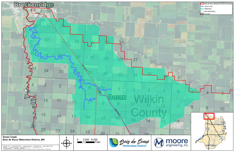
Restoring Natural Stream Flow. The Doran Creek Stream Rehabilitation Project will rehabilitate Doran Creek and restore its natural stream flow by reestablishing the channel and floodplain corridor through the removal of the accumulated sediment. Approximately two to four feet of sediment will be excavated from the channel while completing minor regrading of the banks to restore the floodplain and create a stable condition. An anticipated 428,000 cubic yards of sediment removal is anticipated, which will be spread in adjacent uplands or used to construct project infrastructure when suitable. The project will reestablish a pool-riffle system within the channel to create habitat not present under existing conditions. The project will simultaneously provide an ecological enhancement that will be maintained and protected through the use of perpetual easements and constructed best management practices (BMPs). Project BMPs may require long-term maintenance, which will be achieved through the use of these perpetual easements. The project will be implemented over an approximately 1,400-acre project area, which includes the stream channel and its 10-year floodplain, proposed work limits, and approximately 1,300 acres of proposed conservation easement lands. A brief summary is available here.
Many organizations have supported development of this project, including Bois de Sioux Watershed District landowners, the Red River Watershed Management Board, Watershed Based Implementation Funds through the Legacy Amendment Clean Water Fund administered by the Board of Water and Soil Resources, and the USDA NRCS National Watershed Quality Initiative.
District Cost Share Programs
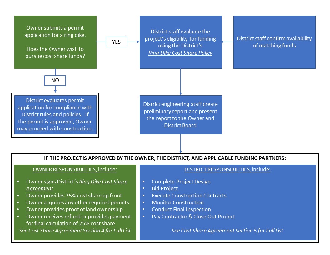
Ring Dike Cost Share Program
Ring Dikes are an important tool to provide protection to property during flood events. Landowners interested in building a ring dike should first fill out a permit application. Outside funding may be availabe. Please review the Ring Dike Cost Share Policy and Cost Share Agreement.
Culvert Sizing Cost Share Program
Culvert sizing can be used to reduce peak flood flows and direct excess flows to temporary distributive storage. The District has implemented a Culvert Sizing Cost Share Program, described here.
Water Quality and Sediment Control
LAKE TRAVERSE WATER QUALITY IMPROVEMENT PROJECT NO. 1
A landowner meeting was held on September 19, 2019 at 1 pm at the Wheaton American Legion to present project costs and possible project funding streams. Landowners had an opportunity to ask questions and provide project feedback. Pictures available here.

An extreme weather event in the mid 1900's cut a deep channel through the sandy hills surrounding Lake Traverse. Over the past 50 years, the channel has deepened, and the current has carried sediment into Lake Traverse - creating a penninsula at the outlet.
In response to landowner requests, Bois de Sioux Watershed Board Managers have made this project a top priority. Phases 1 and 2 are complete. The final phase - Phase 3 - was completed in 2024.
Financial Awards:
Financial awards have been provided by the State of Minnesota BWSR Clean Water Fund Legacy Amendment Act Projects and Practices and Watershed Implementation Fund Grants, the Red River Watershed Management Board, and State of Minnesota Lessard Sams Outdoor Heritage Council DNR Conservation Partners Legacy Grant.