Overall Plan HISTORY
In 2019, an Amendment was made to our Overall Plan. The Amendment was approved by BWSR in 2020.
In 2019, the Lake Traverse Water Quality Improvement Project Phase 1 was added to the District's Overall Plan. The project will stabilize an outlet located directly on Lake Traverse. Extreme erosion has created a penninsula in the lake, from sand carried further uphill.
This project has been awarded a Clean Water Fund Competitve Grant in the amount of $336,775 and the Board of Water and Soil Resources is a sponsoring agency.
In 2020, a Resolution was submitted to extend the current overall plan. The Amendment was approved by BWSR in 2020.
The State of Minnesota Water Plan
The State of Minnesota has its own 2020 - 2030 State Water Plan, and many of the goals and actions are supported by local efforts through the local Joint Comprehensive Watershed Management Plan for the Bois de Sioux and Mustinka River Watersheds. Overlapping goals include:
- Identifying opportunities to retain and store water and manage drainage through established standards for technology, flow reduction, detention locations and sizing, drainage system designs, culvert sizing and flood staging
- Investigating and utilizing funding mechanisms to pay for water retention and detention.
- Development and utilization of multipurpose drainage management standards, guidelines, and incentives.
- Utilization of consistent approaches to drainage system design through adherence to Red River Basin Technical and Scientific Advisory Committee standards.
- Incorporation of drainage water management into our water planning
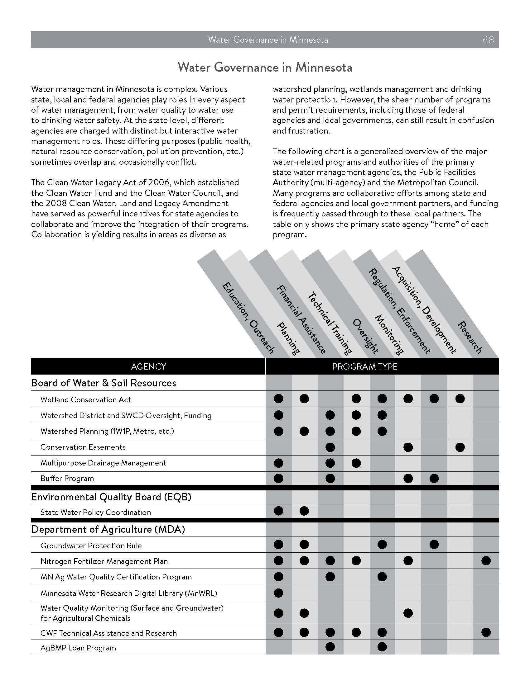
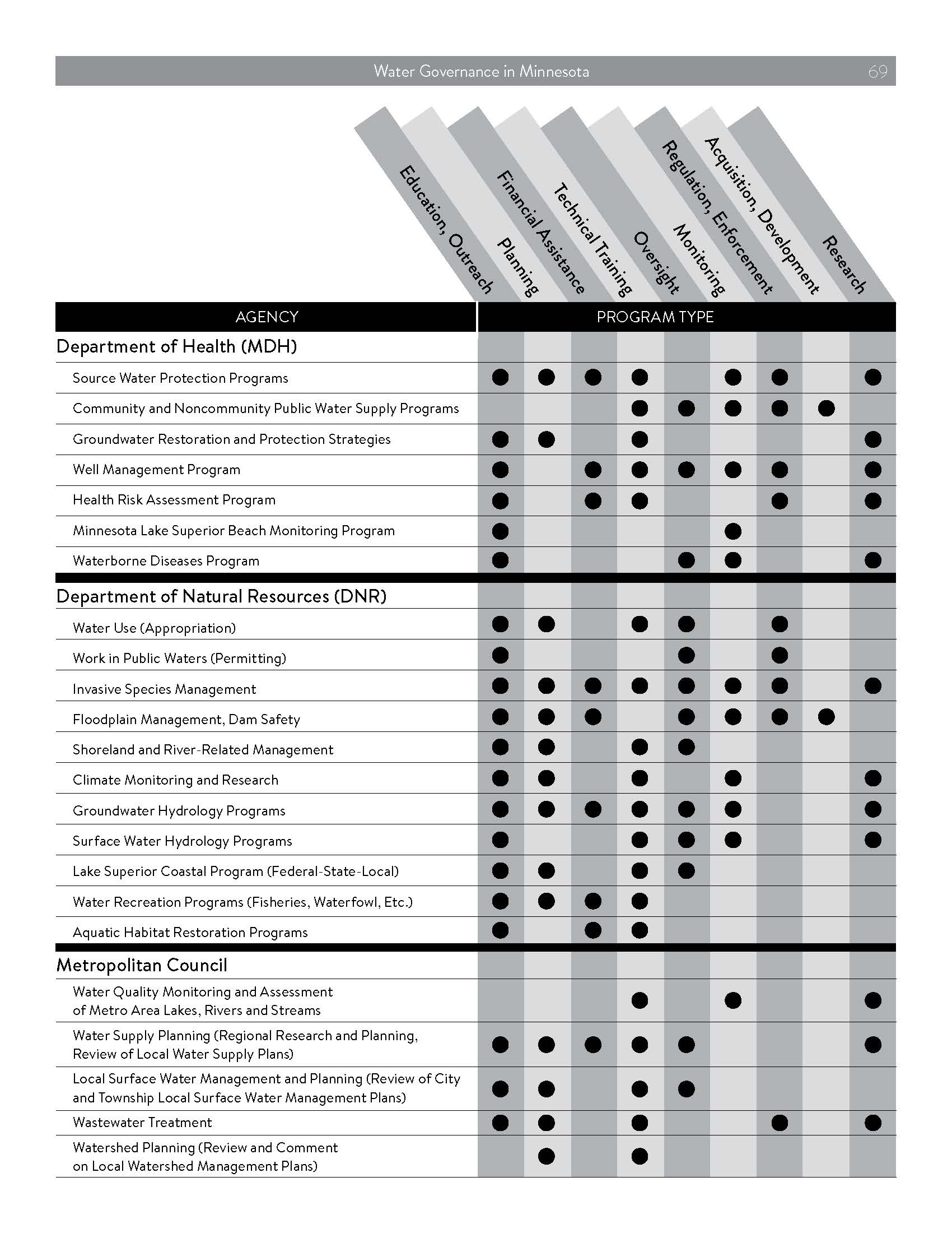
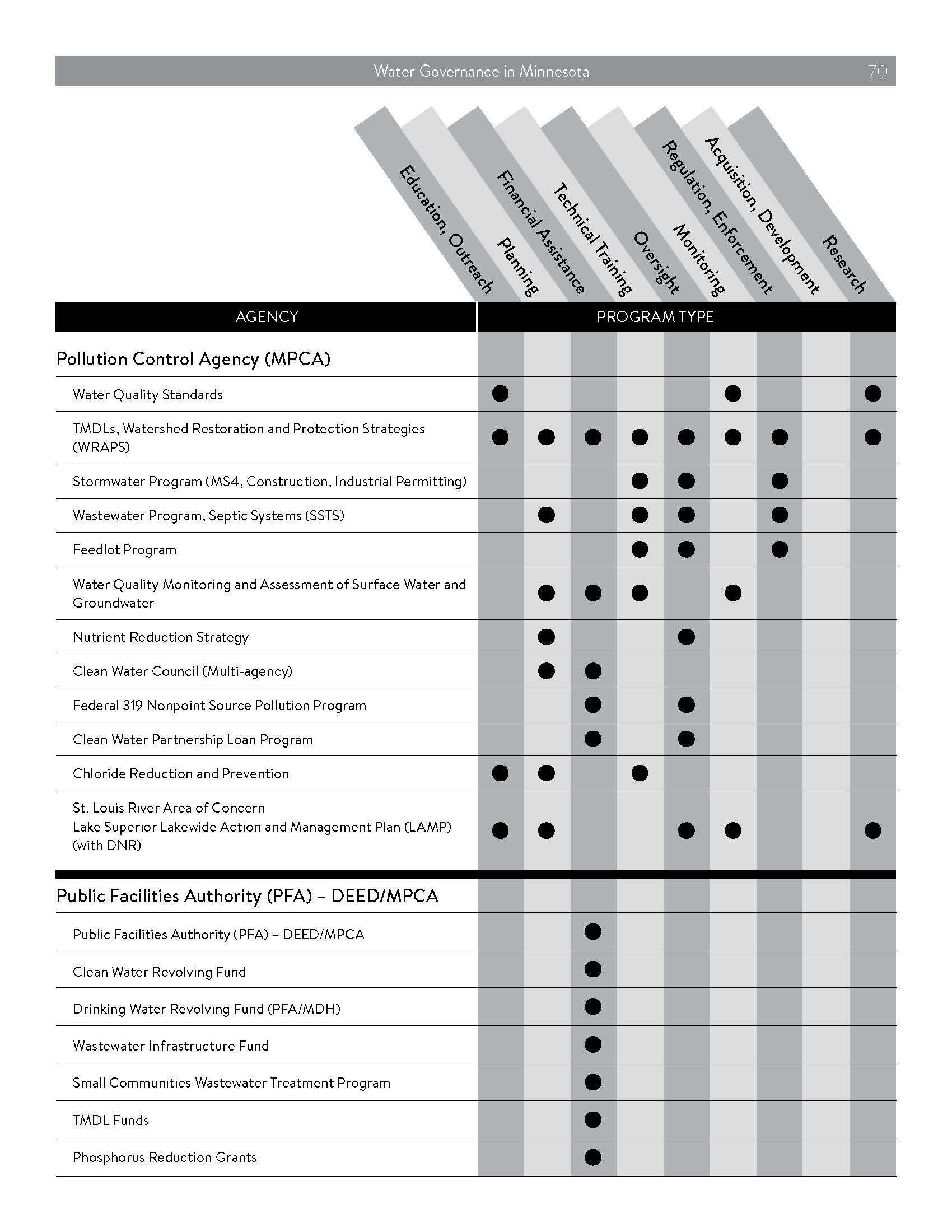
Minnesota Water Framework
Pulled from Minnesota's 2020 - 2030 State Water Plan, the broader regulatory framework for water management in Minnesota is comprised of:
Our Local JOINT COMPREHENSIVE WATSHERD Plan
Annual Updates
2025 Annual Activity Summary, includes accomplishments and progress towards goals
2024 Annual Activity Summary, includes accomplishments and progress towards goals
2023 Annual Activity Summary, includes accomplishments and progress towards goals
2022 Annual Activity Summary, includes accomplishments and progress towards goals
2021 Annual Activity Summary, includes accomplishments and progress towards goals
Meetings
Each of the 13 partnering local government units have appointed a representative to a joint committee for the Bois de Sioux and Mustinka River Watersheds. Meeting agendas, minutes, and committee representation can be found by clicking here.
To contact the Bois de Sioux & Mustinka River Watersheds Joint Comprehensive Watershed Management Plan Committees, please email bdswd@runestone.com or call the Bois de Sioux Watershed District Administrator at 320/563-4185.
The Plan
On January 27, 2021, the Joint Comprehensive Watershed Management Plan for the Bois de Sioux & Mustinka Watersheds was approved. This plan is the product of an intense multi-year One Watershed One Plan planning process. Here is a summary of our findings, and here is our full plan:.
2021 - 2030 Comprehensive Watershed Management Plan
Appendix A - Land and Water Resources Inventory
Appendix B - Planning Memorandum of Agreement
Appendix C - Participation Plan
Appendix D - Plann Comments and Responses
Appendix E - References
Appendix F - State Agency Comments and Letters
Appendix G - Public Issue Results
Appendix H - Surface Water Protection and Restoration Maps
Appendix I - Critical Soil Loss Analysis
Appendix J - Watershed Based Implementation Funding Program by Planning Region
Appendix K - PTMApp Practices
Appendix L - PTMApp Local Decisions and Practice Benefits
Appendix M - BdSWD District Rules, Policies, and Amendments (as of 10/31/2020)
Appendix N - Regulatory Comparison Table
Appendix O - Watershed Capital Improvement Projects
Appendix P - Local Funding Authorities
Bois de Sioux Watershed District History
The Bois de Sioux Watershed District (District) was established on May 11, 1988, by order of the Minnesota Board of Water and Soil Resources (BWSR) under the provisions of the Minnesota Statutes (MS), Chapter 103D, otherwise referred to as the Minnesota Watershed Act. The District is located in west central Minnesota and includes the entire drainage basin, in Minnesota, of the Bois de Sioux River. The counties included in this area are Traverse, Grant, Wilkin, Stevens, Big Stone and Otter Tail. Citi es within the District are Breckenridge, Doran, Campbell, Wendell, Elbow Lake, Norcross, He rman, Donnelly, Graceville, Dumont, Johnson, Wheaton and Tintah. The total area is about 1,412 square miles of which 93 percent is used for agricultural production. The Bois de Sioux River and its source, Lake Traverse, form the boundary between Minnesota and South and North Dakota. The river flows north from Lake Traverse to Breckenridge where it joins with the Otter Tail River to form the Red River of the North. Major tributaries in Minnesota are the Mustinka River and the Rabbit River. Tributaries in North and South Dakota contribute drainage from an additional 549 square miles. The District is a governmental subdivision of the State of Minnesota with authority to comprehensively manage water resources.
Since 2017, the Bois de Sioux Watershed District has been a partner in a collaborative effort initiatied by the Board of Water and Soil Resources (who provided grant funds through Minnesota's Legacy Amendment through the Clean Water Fund), to coordinate water planning amongst multiple local government units. This initiative is called, "One Watershed One Plan." This collaborative effort produced the 2021 Joint Commprehensive Watershed Management Plan that is sponsored in part by two grants from the BWSR Clean Water Fund Legacy Amendment Watershed Based Implementation Funds.
Land Use
The Bois de Sioux River Watershed is comprised of:
- 536 acres of riparian buffers and habitat adjacent to public drainage systems
- 4,949 acres of riparian buffers and habitat adjacent to public waters
- 40,018 acres of habitat - wetlands, grasslands, forests, and open water
- 17,683 acres of urban development
- 297,956 acres of agricultural production.
The Mustinka River Watershed is comprised of:
- 840 acres of riparian buffers and habitat adjacent to public drainage systems
- 4,244 acres of riparian buffers and habitat adjacent to public waters
- 72,217 acres of habitat - wetlands, grasslands, forests, and open water
- 26,987 acres of urban development
- 451,226 acres of agricultural production
Agricultural Production
Our region is comprised of prime farmland, and our producers sustainably grow:
- US Soybeans
- US Corn
- US Wheat
- US Sugar
- US Dairy
- US Pork
- US Poultry, Turkey, and Eggs
- US Beef